


E300 Pro
Full-featured RTK Receiver
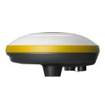
The eSurvey E300 Pro is a fully functional GNSS receiver with an extremely compact design by eSurvey GNSS. With its high-performance GNSS board, it can track all present constellations and satellites. The GNSS, Wi-Fi, Bluetooth, and GSM four-in-one antenna, stable data transmission, RTK Aid, and IMU function, make it suitable for all surveying applications.
FEATURES
Quickly check the remaining battery power in real time and figure out the working time without data loss.
Integrated Tx/Rx UHF Modem in a Compact Design
The built-in transceiver radio modem in the compact design of the E300 Pro makes it a full-featured and portable GNSS receiver that works as either base or rover station.
Rugged Design: Better Resistance to Shock and Fall
Use it for many years, for it is strongly made and capable of withstanding rough handling.
RTK Aid Function: Uninterrupted Work
Work without interruption even when RTK corrections fail, powered by our RTK aid function.
Multi-constellations and Multi-frequency
With 1408 channels of GNSS tracking, the E300 Pro provides stable and reliable centimeter-level positioning accuracy in real-time to suit any field data collection applications. All GNSS signals are supported, including GPS, BDS, GLONASS, GALILEO, QZSS, SBAS, L-Band and IRNSS.
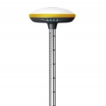
Max 60° Tilt Survey: A Different Way of Working
· Quickly measure accurate points while standing or walking without leveling the pole.
· Concentrate on where the pole tip needs to go, which is especially useful during a stakeout.
· Easily start a survey in environments that are hard to reach, such as building corners and slopes.
· No longer worry about the movement of the pole when measuring, provided that the pole tip is stationary.
SPECIFICATIONS
|
GNSS
Performance |
E300
Pro |
|
|
Satellites tracking |
GPS |
L1CA, L2P(Y), L2C, L5 |
|
BDS |
B1I, B2I, B3I, B1C, B2a, B2b1 |
|
|
GLONASS |
L1, L2 |
|
|
GALILEO |
E1, E5a, E5b, E61 |
|
|
QZSS |
L1, L2, L5, L61 |
|
|
IRNSS |
× |
|
|
SBAS |
WAAS, GAGAN, MSAS, EGNOS, SDCM,
BDS |
|
|
L-Band |
B2b PPP (Only for the Asian-Pacific
region) |
|
|
Channels |
1408 |
|
|
Signal reacquisition |
× |
|
|
Cold start |
< 30 seconds |
|
|
Warm start |
< 20 seconds |
|
|
Hot start |
< 5 seconds |
|
|
RTK signal initialization |
< 5 seconds |
|
|
Initialization reliability |
> 99.9% |
|
|
Update rate |
20 Hz |
|
|
High precision static |
- H: 2.5 mm + 0.1 ppm (RMS) - V: 3.5 mm + 0.4 ppm (RMS) |
|
|
Static and Fast Static |
- H: 3 mm + 0.5 ppm (RMS) - V: 5 mm + 0.5 ppm (RMS) |
|
|
RTK |
- H: 5 mm + 0.5 ppm (RMS) - V: 10 mm+0.5 ppm (RMS) |
|
|
Standard point positioning |
- H: 1.5 m (RMS) - V: 2.5 m (RMS) |
|
|
Code differential |
- H: 0.4 m (RMS) - V: 0.8 m (RMS) |
|
|
SBAS |
- H: 0.3 m (RMS) - V: 0.6 m (RMS) |
|
|
Correction data |
RTCM V3.X, RTCM2, CMR |
|
|
Data output |
GGA, ZDA, GSA, GSV, GST, VTG,
RMC, GLL, Binary |
|
|
Power Supply |
||
|
Battery |
Rechargeable Built-in Lithium-ion battery x 1 7.2 V ~ 6800 mAh |
|
|
Voltage |
9 - 28V dc |
|
|
Working time |
Up to 12 hours |
|
|
Charging time |
Typically 4 hours |
|
|
Internet
Modem |
||
|
Supported band |
Global 4G - LTE FDD: B1, B2, B3, B4, B5,
B7, B8, B12, B13, B18, B19, B20, B25, B26, B28 - LTE TDD: B38, B39, B40, B41 - UMTS: B1, B2, B4, B5, B6, B8,
B19 - GSM: B2, B3, B5, B8 |
|
|
System |
||
|
Operation system |
Linux |
|
|
Internal memory |
8 GB |
|
|
Bluetooth |
BT 5.0 + EDR, BLE |
|
|
Wi-Fi |
802.11a/b/g/n/ac |
|
|
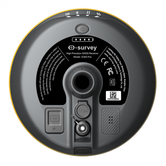
SIM card |
yes |
|
|
TF card |
× |
|
|
TNC |
Connect internal radio with
antenna |
|
|
5-pin port |
Connect to external radio and
external power; NMEA output |
|
|
7-pin port |
× |
|
|
Type-C port |
Charge and data transmission |
|
|
Web UI |
View status, update firmware, set
up working mode, download data, etc. |
|
|
Intelligent voice |
Broadcast working mode and status |
|
|
MEMS |
Fast initialization, dynamic tilt
survey up to 60° |
|
|
Physical |
||
|
Dimension |
158 mm x 53 mm |
|
|
Weight |
940 g |
|
|
Operating temperature |
-30℃ - +65℃ |
|
|
Storage temperature |
-40℃ -
+80℃ |
|
|
Water/dustproof |
IP67 |
|
|
Shock |
- Withstand topple over from a 2
m survey pole onto hard surfaces - Survive a 1.2 m free drop |
|
|
Vibration |
Vibration resistant |
|
|
Humidity |
Up to 100% |
|
|
Indicators |
Satellites, datalink, battery,
Bluetooth |
|
|
Button |
The power button, short press to
voice broadcast working mode and status |
|
|
Screen |
× |
|
|
Certificate |
CE, FCC, NGS, IGS |
|
|
Internal
Radio |
||
|
Type |
TX and RX |
|
|
Emitting power |
1 W |
|
|
Operation range |
- 3 - 5 km typically - 10 km with optimal conditions2 |
|
|
Frequency range |
410 - 470 MHz |
|
|
Channel spacing |
6.25 KHz3 / 12.5 KHz / 25 KHz /
280 KHz4 |
|
|
Protocol |
Satel, PCC, TrimTalk, TrimMark
III, TRANSEOT(PCC-GMSK), South, HiTarget, GEOTALK, GEOMK3, HZSZ, 900M
Hopping4 |
|
PACKAGING
