


G40
GINTEC G40 AR GNSS receiver with revolutionary vision technology. Experience real-time visual layout, eliminating repetitive pole adjustments. Our professional-grade camera ensures clear visibility even in challenging lighting conditions. Our fusion algorithm combines satellite and inertial navigation with visual perception, replacing outdated compass-based systems. Enjoy unparalleled accuracy without magnetic interference. With 1408 channels, the G40 enhances fixed performance by an outstanding 20% even in obstructed environments. Upgraded with our GINTEC 5 satellites + 21 frequencies solution engine, the chip’s computational power is boosted by 40%, enabling precise calculations using a wider range of satellite frequencies. With 1408 channels, the G40 enhances fixed performance by an outstanding 20% even in obstructed environments. Upgraded with our GINTEC 5 satellites + 21 frequencies solution engine, the chip’s computational power is boosted by 40%, enabling precise calculations using a wider range of satellite frequencies.
-
catalog
- G40.pdf (7.8M)
- Product Specifications
-
-
-
-
-
-
-
-
-
-
-
-
-
-
FEATURES
New-Generation SoC
Powerful GNSS SoC chip with 1408 channels
Supporting the new B1C, B2a, B2b, and BeiDou-3
G-FIX supported
Calibration-Free Tilt Compensation
Calibration and initialization FREE
Ready for tilt survey straight out of the box
G-FIX Correction Outage Technology
Extending RTK positioning up to 10mins
Reducing downtime waiting to re-establish RTK corrections
Built-in Battery. Quick Charge
Supporting USB 3.0/45W quick charge
Charging time ≤ 3.5 Hours
Battery Life ≥ 2000 Circles
New Antenna Combination
Highly integrated GNSS,4G, WIFI, and Bluetooth antennas
Powerful Performance. Smaller Size
Anti-Interference Technology
Advanced multi-frequency interference suppression and multi-step adaptive filtering technology
Strong and stable signals in challenging conditions
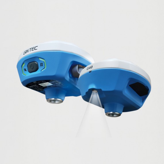
Augmented Reality (AR)
Overlaying digital information onto the real world
Assisting to view the stakeout location and see designed features in real time
Professional Camera
High-resolution Night vision camera
Broad perspective, sophisticated algorithms guaranteeing the precision up to 1cm
Seamlessly combining 360-degree AR layout and image layout
G-FIX Correction Outage Technology
G-FIX Correction Outage Technology refers to the use of methods and techniques to mitigate the effects of GNSS correction data loss or outage,which is used to improve the accuracy of positioning by correcting errors caused by atmospheric and other environmental factors.
Widely used in
Surveying and Mapping / Geographic Information System / Agriculture / Aerospace / Oceanography and hydrology / Road and transportation / Construction
Brand-New Calibration and initialization FREE IMU
By utilizing a highly accurate Inertial Measurement Unit (IMU) and a unique tilt compensation function, RTK tilt measurement has been made practical.
No calibration required, GINTEC G40 RTK is ready for precise measurement from the moment when it is turned on, allowing instant use.
It is resistant to magnetic interference, making it suitable for use in any location.
RTK measurement is no longer bound by bubbles, realizing an efficiency improvement of at least 30%, and greater measurement accuracy is guaranteed.
AR Stakeout
Use an AR tool to visualize the location and position of a design feature or structure on a real-world site.This involves using a GNSS receiver to locate the position of the design feature or structure on the site, and then overlaying an augmented reality image of the feature onto the real-world view.This process helps the surveyors to accurately stake out the location of the feature or structure and ensure that it is built according to the design specifications.
SPECIFICATIONS
POSITIONING
Channels 1408
GPS L1 C/A,L1C, L2P(Y), L2C, L5
GLONASS G1,G2,G3
BEIDOU B1L,B2L,B3L,B1C,B2a,B2b
GALILEO E1, E5a, E5b, E6
QZSS L1C/A,L1C,L2C,L5
NavlC L5
SBAS L1C/A
Cold Start <12s
Initialization Time <5s
Initialization Reliability >99.9%
ACCURACY
Static Accuracy H:±2.5mm+0.5ppm
V:±5.0mm+0.5ppm
RTK Accuracy H:±8.0mm+1ppm
V:±15.0mm+1ppm
Time Accuracy 20ns
Update Frequency 20Hz
POWER
Battery Built-in Battery,6800mAh 3.6V
Duration ≥18.5h
Input 5V/2A DC
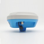
PHYSICAL
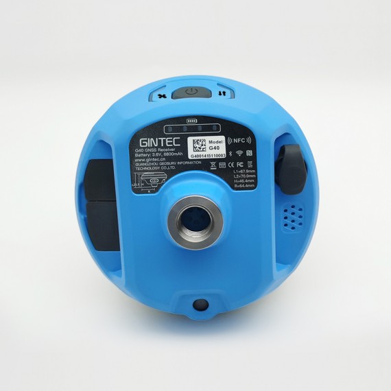
Material Magnesium alloy main body. ABS/PC top cover
Dimensions 130mm*130mm*70mm
Weight 750g
OPERATION
Button Power Button
Indicator Satellite,Datalink, Power
SYSTEM
Operation System Linux
Memory 8GB Internal Storage
Bluetooth V5.0, BLE
WIFI 802.11a/b/g/n
4G Network LTE FDD: B1/B2/B3/B4/B5/B7/B8/B12/
B13/B19/B20/B25/B26/B28
LTE TDD: B38/B39/B40/B41
UMTS: B1/B2/B4/B5/B6/B8/B19
GSM: B2/B3/B5/B8
Internal UHF Power: 1W
Frequency: 410~470MHz
Protocol: Gintec Work、TrimTalk450s(T)、TrimMark III、SOUTH、PCC-EOT、Hi-Target、GeoTalk、GeoMark、SATEL
Tilt Survey IMU Tilt Survey Compatible with SurPad
CAMERA
2Mega CMOS image sensor
Optical Format 1/5 inch
Pixel Size 1.75um*1.75um
